Crossing the Gulf Stream can be thrilling and humbling in equal measure. Here’s how to avoid the most common mistakes—from leaving too late to locking into a plan—and make your Bimini to Fort Lauderdale passage smoother, safer, and more rewarding.
JUMP TO
- Timing Your Crossing
- Preparation Resources
- Recommended Safety Gear
- Step-by-Step Preparation Timeline
🌡️ The Gulf Stream
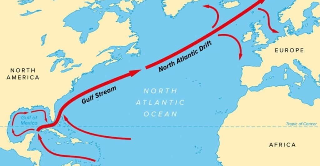
The Gulf Stream is a powerful, warm ocean current flowing from the Gulf of Mexico through the Straits of Florida along the U.S. eastern coast. Off Florida, it’s sometimes called the Florida Current and is known for bringing warm, clear water close to shore.
The current plays a significant role in the region’s weather, marine life, and maritime navigation—and it defines the challenge for anyone sailing between the Bahamas and Florida.
⚠️ The Challenges of the Gulf Stream
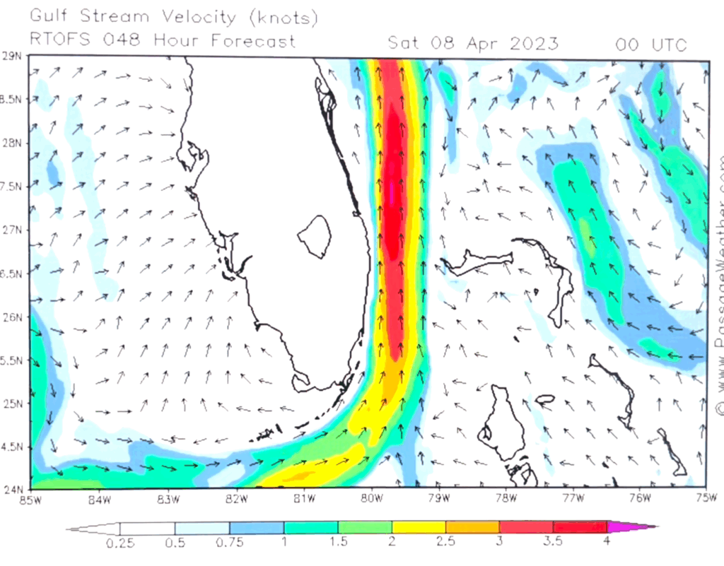
The Gulf Stream flows north at a steady 2-4 knots (sometimes up to 5+), and that current alone is enough to shape your entire crossing. If you simply point your boat at your destination and let the autopilot do the work, you’ll almost certainly end up well north of where you intended. For instance if you go from Bimini and point directly at Fort Lauderdale, you will likely end up closer to Palm Beach. Careful course planning is part of the adventure.
The bigger danger, though, is when the weather doesn’t play nice. Northerly winds blowing against the Stream can whip up square, angry seas that no cruiser wants to tangle with. Even a modest 10–15 knots from the north can turn the ride into a punishing bash. Add in the summer habit of afternoon squalls and thunderstorms, and you quickly see why choosing your window is everything.
On top of the natural challenges, this is a busy stretch of water. Cargo ships, tankers, and cruise liners converge on the major ports in Florida. Keep a sharp eye on AIS, radar, and the horizon.
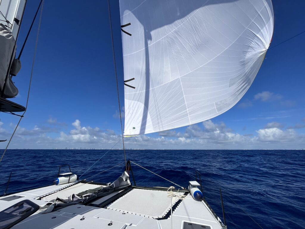
Out on the Stream, the water feels alive—the deep, rolling blue, heat rising off the horizon, flying fish skimming across the waves. It’s a stretch of ocean that humbles and thrills in equal measure.
🌬️ Choosing the Right Window
The first rule is simple: don’t go with northerly winds. Instead, wait for a day when the forecast shows light southerlies, easterlies, or calm conditions. Many sailors linger at their jumping off point until the weather lines up. A good rule of thumb would be to have 10 knots from the east and less than 15 knots from the west with a southerly component.
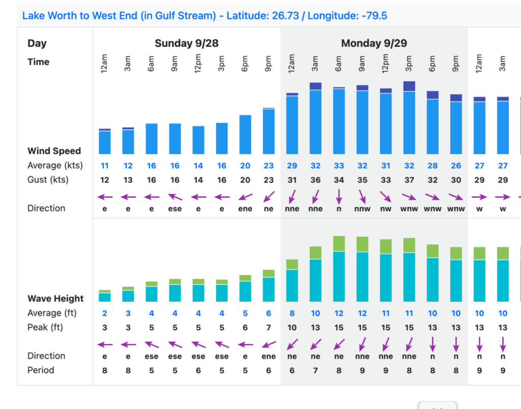
Most cruisers aim for a first-light departure, giving themselves plenty of daylight to cross before Florida’s late-day convection builds.
We departed Bimini for Fort Lauderdale before sunrise at 4AM. It’s worth the early alarm—casting off at dawn and watching the pink and gold of sunrise spill across the water is its own reward. Heading east, we left in the evening for an overnight crossing from Fort Lauderdale to Great Harbor Cay. It allowed us to arrive during the day and get a bit farther into the Bahamas.
🧭 The Crossing
Getting your heading right is essential. From Bimini to Fort Lauderdale, for instance, the course may look like a straight west line, but the Stream pushes you north, so steer slightly south—often 270–280°.
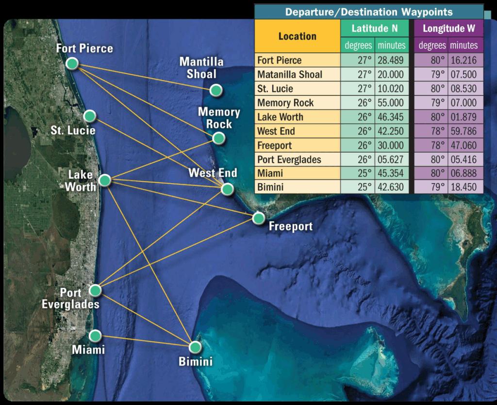
I found both of these images floating around the internet from various places. We used these as a starting reference to set our intial headings and adjusted over time from there.
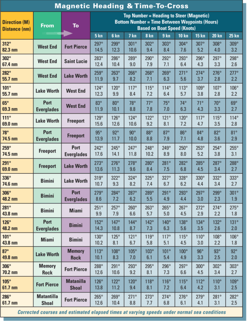
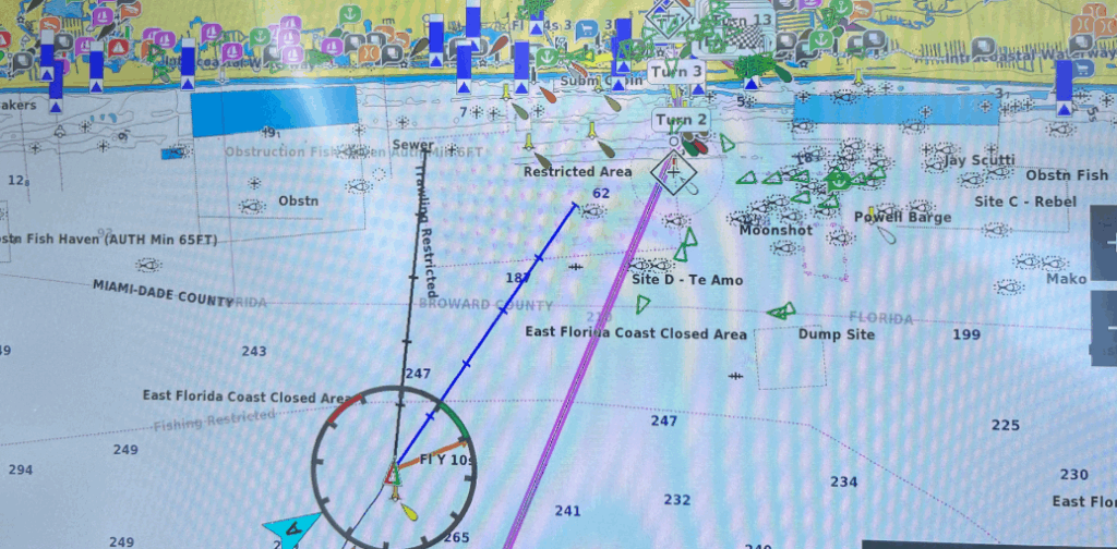
The trick is not to overdo it. Make small adjustments, check your progress often, and let the boat find its rhythm. We started out. On a heading of 260 and only adjust slightly north as we neared the Port Everglades Inlet. Better to undershoot than overshoot and have to fight the current to get back south.
⚓ Pro Tip: Use the Course Over Ground (COG) line on your chart plotter to ensure you’re tracking toward your destination.
For an easier crossing to the Bahamas, consider departing from more southern locations like Marathon, Point Lookout, or Miami.
⚓ Common Pitfalls That Make for a Rough Crossing
Even with all the planning in the world, the Gulf Stream has a way of humbling sailors who rush their window or cling too tightly to a plan. As aviators, we called this “get-home-itis” or the feeling of a compelling need to depart even when you know the timing isn’t optimal or conducive to a comfortable passage. We’re pretty sure weather doesn’t care about your plans or feelings.

⏰ Departing Too Late
Departing too late. It’s easy to linger when the weather looks grim, telling yourself you’ll start prepping once it clears. But by the time the sun’s shining and the seas settle, the clock is already ticking on your good window. The smartest sailors use the stormy days to ready the boat, so when conditions improve, they’re already untying the dock lines. Once again as aviation has taught us, the “runway” behind you is useless now.
🌩️ Leaving as Conditions Worsen
Just because it looks fine now doesn’t mean it will stay that way. The Stream magnifies everything—especially northerly winds. If the forecast shows a shift from calm to north later in the day, wait. The temptation to “sneak across” before things get rough often leads to a long, pounding ride instead of a smooth passage. (this is vessel speed dependant and you must account of that in planning.)
🧭 Forcing Decisions Too Early
We all love a tidy plan, but offshore weather rarely cooperates with calendars. Stay flexible. Etch your plans in sand, not stone. The more options you leave open and the later you make your decision, the easier it is to adapt to updated forecasts, unexpected equipment hiccups, or a changing sea state.
🚫 Being Inflexible Once Underway
Sometimes the destination, schedule, or crew expectations can lock us in mentally. But the ocean doesn’t care about our plans. A shift in wind, a squall line, or a crew member feeling green might call for a new heading—or even a new port altogether. The best captains know when to pivot. (“PIVOT!” -Ross)
Bottom line: Success on the Stream is less about perfection and more about patience. Choose your weather window wisely, stay humble, and give yourself permission to adapt. When you do, the Gulf Stream rewards you—not with an easy ride, necessarily, but with one that feels earned, balanced, and deeply satisfying.
🧰 Preparing for the Perfect Window
Once you’ve learned to respect the Stream’s moods, preparation becomes your best ally. From watching the forecasts to checking safety gear and plotting your course with care, every small step builds confidence.
Below, you’ll find the same resources, safety checklists, and step-by-step preparation timeline we used to plan our own crossing — tools that made all the difference. We have been lucky enough to have had 3 fairly benign crossings. I really hope I didn’t just jink us…
Weather & Stream Resources:
- Windy App – Our first stop for all things weather, stream, wave, etc related. More detailed info for the Gulf Stream can be found here.
- Marv’s Weather – Free service that shares off-shore daily virtual buoy reports and their tropical weather reports and forcasts for Florida, Bahamas and Caribbean. Go to the Crossing Florida to Bahamas or Miami to Bimini for Gulf Stream forcasts over the next 2 weeks. You can also sign up for daily emails of their various reports with a free account.
- PassageWeather Stream Map – stream map. You can get all sorts of current, wind wave data for all over the world navigating from their homepage.
- Predict Wind – We use this prior to every passage to put in routing and figure out best timing. We update it every 12 hours while on passage to see any changes to expected weather patterns before they become a problem.
- NOAA / National Data Buoy Center / NWS Marine Forecasts – NOAA near term forecasts. A great site to get localized conditions for the crossing.
Marine Weather Center – Also known as “Chris Parker”. Offers varying degrees of paid services for routing and forecasts. We have used him for some longer more dynamic passages such as rounding Hatteras or multi-day sails over longer distances mostly to back up our own thoughts vice relying solely on his services. Our thoughts are that he is VERY consertive in his forecasts; We have opted to depart during times he has stated that “departing today will lead to a salty sail” which is his team’s terminolgy for “this will be a rough sail.” All of this depends on your comfort level and experience.
SailFlow – Another worldwide weather forecasting site with it’s own unique algorithms for crunching wind/wave data.
Customs and Immigration Resources
- Reporting into US: Customs and Border Protection – Free mobile App for U.S. Customs and Border Protection for applications to report Offsite arrival. It allows pleasure boaters to report their arrival in the U.S. from a foreign port or place using their smartphone or tablet.
- Reporting into Bahamas: Click2Clear – the official online portal for the Bahamas Customs used by individuals, businesses, and travelers arriving by sea or air to complete customs declarations and pay for permits, including cruising permits for vessels and those for pleasure aircraft.
- Noonsite: We can’t stress using this site enough; It is a one-stop-shop for cruisers that provides comprehensive information for planning international sailing trips. It offers details on country and port entry/exit formalities, port and marina facilities, cruising news, and other resources for boaters who sail beyond the horizon.
🛟 Recommended Safety Items
Gear – not all encompassing but some big things we thought about.
- Life Jackets with tether lines attached to them. We use Spinlock Deck Vests onboard Water Wings. (Be advised, the D6 is NOT USCG compliant. We use it anyways as our primary vest and have a locker full of compliant vests.)
- Personal Locator Beacon – We also attach AIS MOB1 devices to our vests. It is a personal locator beacon (PLB) for MOB situations, which automatically activates when submerged. It uses Automatic Identificaion System (AIS) to transmit its precise GPS location to nearby boats and also triggers a Digital Selective Calling (DSC) alarm, greatly increasing the chances of a swift rescue.
- Jack lines – Generally run them from bow to stern. Attach your tether line when walking on deck in rough seas.
- Throwable Flotation Device – Should a man-overboard situation arise. Off-shore we recommend a Jon Buoy with Danbuoy and Horseshoe.
- Chart plotter – to route and track progress.
- Radar & AIS – to track weather and traffic around you.
Communication – Again there is more, but these are some basics.
- VHF Radio tuned into channel 16 for international hailing and distress calls.
- Communication Devices – Garmin InReach or other Communication Device that allows communication outside of VHF range. Updates your position and can send update messages for anyone monitoring your progress. You can also use as an emergency beacon if search and rescue is required, and get weather updates if needed on some models.
- EPIRB (Emergency Position Indicating Radio Beacon) – Deployed in the event of an emergency to help search and rescue assets locate you.
- Iridium Go – slowly being phased out with Starlink, but a great option for a rugged, portable satellite hotspot that connects to the Iridium satellite network to provide voice calls, SMS text messaging, and GPS tracking via a smartphone or ipad app. We used this crossing the Atlantic when we didn’t have Starlink and honestly, will use as a back up to Starlink should we cross another ocean.
- Starlink – Starlink provides reliable, high speed internet service in remote ocean locations where cellular and traditional satellite services may. be unavailable, enabling crucial activities like real-time weather updates, communication with shore and other boats, remote work, and entertainment. there are different packages available and reliablity in different regions needs to be researched. Recommend you have a back up plan if you will be traveling outside your normal cruising grounds.
Tips: Check all gear before departure and ensure crew familiarity.
Check out our additional safety gear recommendations HERE.
📋 Step-By-Step Preparation Timeline
Quick prep summary example (Bimini – Fort Lauderdale)
Offshore distance ≈ 50 NM (actual distance depends on Bimini slip/anchorage and chosen Fort Lauderdale entry).
Expect a northward Gulf Stream set — plan to steer some degrees south of a direct line to counter the set. The Stream commonly runs 1–3+ knots (occasionally more); check current forecasts before departure. National Ocean Service+1
T-48 hours — Weather & Route Confirmation
- Check the forecasts for the area between Bimini and SE Florida (Atlantic waters, Fort Lauderdale/Port Everglades zone).
- Daylight departure if possible. If not plan to arrive in daylight. Bonus if the sun is behind you arriving in the Bahamas to help you see coral heads as you head in to anchor.
- Course set with allowance for the set and drify of the Stream.
- Fuel, sails, and customs plan ready.
- Seas < 4 ft preferred / period of waves preferably at least triple the height. (3’ at a period of 9s or more)
- Forecast: no N winds in the next 24 hours. Do not go if northerly winds (N/NE/NW) are forecast to be steady or gusty — wind against the Stream produces steep seas. If winds are light southerly/easterly or variable, you’re in a better window.
- Check the the Customs and Immigration Requirements. See the Resources section above.
T-24 hours — Boat & Crew Readiness
- Safety gear: lifejackets, harnesses, jacklines rigged, EPIRB/PLB checked and battery-tested, throwable, first aid kit stocked.
- Fuel: top off tanks. You will likely motor a portion or motor-sail; have reserve for unexpected headwinds or detours.
- Sails & rigging check: reefing lines ready, halyards cleated, preventer if you have one.
- Provisions: water, snacks, seasickness meds accessible. Crew briefed on watch schedule, man-overboard plan, and where safety gear is.
- Navigation: download offline charts of the route, load routing waypoints into chartplotter, and verify AIS/radar (if fitted) are working.
T-2 hours — Final Checks & Brief
- Final weather check (latest NWS/NOAA and any local buoy observations). Confirm no developing cold front or squall line that will affect the crossing. National Data Buoy Center+1
- File or share float plan with a friend/marinas/VHF contact (departure time, estimated arrival, boat description, contact phone). You can get more info and a template from the USCG How to File a Float Plan Webpage HERE.
- Confirm CBP ROAM readiness (if using app): have passport, vessel documents, and photos ready on your phone. Customs and Border Protection
Departure
- Depart when you can take advantage of the most daylight and avoid late-afternoon convection/squalls that commonly pop up in that area.
- Set an initial course south of the direct line. As a rule of thumb from Bimini many sailors initially steer well west-southwest to west (e.g., roughly in the 270°–280° range from local charts) then trim course as you observe actual set. Don’t over-correct; small adjustments work best. (Use real-time position and track to judge set.)
- Use a combination of pilotage and dead-reckoning with frequent GPS cross-checks. Keep an eye on SOG vs. STW to estimate current strength.
Underway Routine (maintain good seamanship)
- Watch schedule — Set a schedule that makes sense for you especially if going overnight so that someone is always on deck.
- Helm & course — monitor GPS track and waypoint cross-track error (XTE). If you’re being pushed north, gradually bring the bow more south to compensate (small changes). Large changes will lead to you making no progress eventually pointing directly into the current
- Speed & sail plan — Reef early if winds and seas build. If the wind is light and Stream strong, be prepared to motorsail. Keep sails managed to avoid accidental jibes.
- Traffic —When departing or arriving into a Florida port you will likely encounter high-traffic: monitor VHF 16, AIS, and radar; make early and unmistakable helm/engine signals when crossing shipping lanes. Be prepared to alter course for large commercial vessels. Navigation Center+1
- Weather watch — squalls build in the afternoon; if you see cumulonimbus or radar echoes, put on lifejackets and prepare for heavy weather.
Arrival checklist (within 30–60 minutes of dock)
- Find a good protected spot to anchor (hopefully having already decided which anchorage is your destination prior to departure or Contact port/marina for a slip assignment and approach instructions.
- Approach at safe speed; have docking lines and fenders ready.
- Raise your Q-flag
- When returning to the US, Complete CBP ROAM check-in (or present yourself to the assigned CBP officer). Customs and Border Protection
- When arriving to the Bahamas, contact the nearest Customs and Immigration Office with appropriate paperwork (NOONSITE LINK)
Emergency Plan (if things go wrong).
If crew overboard: shout, throw a flotation, mark position on GPS, maneuver to recover, and deploy MOB alert on plotter/AIS if fitted.
If seas build beyond safe limits: reef immediately, reduce sail, consider heaving-to or running off before making final approach.
If dismasted or disabled: send MAYDAY on VHF CH16, activate EPIRB, and transmit position/intentions to USCG if able.
Arrival checklist (within 30–60 minutes of dock)
Find a good protected spot to anchor (hopefully having already decided which anchorage is your destination prior to departure or Contact port/marina for a slip assignment and approach instructions.
Approach at safe speed; have docking lines and fenders ready if necessary.
Raise your Q-flag
Check in – When returning to the US, Complete CBP ROAM check-in (or present yourself to the assigned CBP officer). Customs and Border Protection When arriving to the Bahamas, contact the nearest Customs and Immigration Office with appropriate paperwork.
🌅 Final Thoughts
Crossing the Gulf Stream is never just “another hop.” It’s a rite of passage for sailors heading between the Bahamas and the U.S. east coast. With the right prep and the right weather, it can be a glorious day on the water—a straight-line bridge between two worlds, carrying you from the slow rhythm of the islands back to the bustle of Florida.
How did our first crossing go? You can read about it HERE. Or watch the YouTube video HERE.

Discover more from Water Wings Sailing
Subscribe to get the latest posts sent to your email.